
DELTA UAV SERVICES

LEADERS IN UAV AND DRONE IMAGERY FOR ALL SCOPES OF WORK
SERVICES

NDVI Crop
Inspection
Get real-time, up-to-date high resolution NDVI and near-infrared imagery to asses the health of your crop. Pick out stressed areas before even your eye could see the damage.
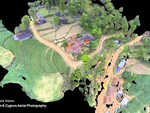
Acreage Mapping
We can create ultra-high resolution 2D and 3D orthomosaic maps of your farm or property. These are created by stitching ogether hundreds or thousands of high resolution photos into one single image that can be overlayed into google earth, or printed in large format.

Insurance Claim Analysis
Our UAVs can fly and photograph fields or whole farms and the damaged area can be accurately assesed and measured, without setting foot in a field.

Elevation Mapping
We can create accurate, high quality elevation maps using the latest technology. All done in a fraction of the time as a human based approach.

Roof Surveys
Complete Accurate Roof Inspections, Measurements & Reports with Drones. We can quickly plan an automated drone flight and capture high-resolution roof imagery in as little as 10 minutes — without the need to ever step foot on a roof. Each roof report provides accurate square footage, roof features, pitch, surface area, and slope. And you can rest easy knowing all the measurements are 99.4% accurate. Once your roof report is ready, we will send a PDF copy or export a DXF output compatible with your existing tools.

Commercial Property
Photography & Filming
Nothing else gives you a scale and perspective for your project quite like photography and video from above. We combine still photography & aerial video shoots to save time & money. The final product gives our clients the ultimate low cost marketing tool to increase sales and boost awareness. We have the ability and expertise to produce high quality, high impact imagery that will make your business stand out and give it the competitive edge. We also work one to one with local businesses from all sectors helping to promote their products and services through stunning imagery.
ABOUT
Delta UAV Services is a full-service UAV and drone imagery and analysis company with a wide array of drones and software available to complete your project, no matter how large or small. Our services are available to anyone, across many different industries including agriculture, construction, energy, insurance and the public sector. The services we provide will help transform the way our clients do business. With quicker and more accurate data processing capabilities, drone technology is disrupting industry standards. We help our clients reduce cost, timelines and risk with drone technology
PROJECTS


CLIENTS


CONTACT
Inquiries
For any inquiries, questions or commendations, please call: 662-820-3980 or fill out the following form
Home Office
3180 Highway 82 East
Greenville, MS 38703
Cell: 662-820-3980
Office: 662-332-3683